
Anticipating flood-related 112 calls using machine learning
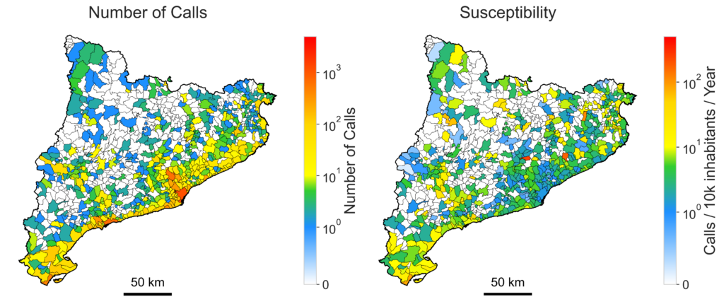
A study exploring the use of machine learning algorithms for the prediction of 112 in a flood context has recently been published in Natural Hazards and Earth System Sciences (NHESS). The study was conducted by Jordi Morales (HYDS and UOC), Andreas Kaltenbrunner (UPF), Agata Lapedriza (Northeastern University and UOC), and Xavier Llort (HYDS).
Currently, most forecasts and early warning systems rely on hazard-based approaches for the prediction of potential hazards with significant risk to the population. However, as extreme weather events become more frequent and intense, it is increasingly pressing to provide more accurate predictions that take into account information about vulnerable and exposed elements. The GOBEYOND project directly targets this issue by driving the development of early warning systems that are impact-based. Accordingly, this new research aligns directly with GOBEYOND’s objective by presenting an ML approach that combines rainfall-related data with information on vulnerable and exposed elements to predict whether 112 emergencies will occur in the following hour, at the municipal scale and with an hourly temporal resolution.
In total, several models were trained targeting different population density groups (low, medium, and high density). Results were compared against currently operational, hazard-based systems such as official weather warnings over a period of nearly six years (October 2018 to February 2025) in Catalonia, Spain. Moreover, additional experiments were conducted to understand the underlying behaviour of the models.
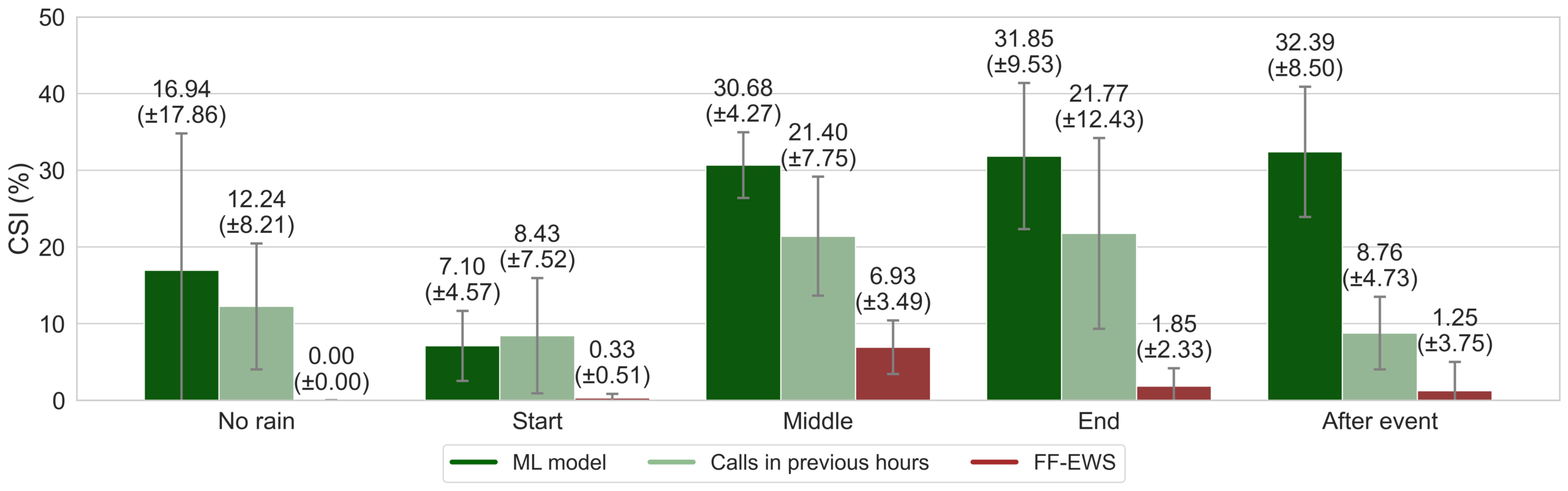
The key results show that the ML approach represents a substantial improvement in two out of the three groups compared to more traditional methods, both in the reduction of false alarms and in the detection of impacts. The model for the lowest-density group, however, struggles due to a substantial lack of impact data, highlighting a key roadblock for data-driven algorithm development in sparsely populated regions.
Further experiments on model behaviour also reveal how the ML model performs across different stages of a rainfall event, highlighting not only the hours when rain begins (where performance, although reduced compared to subsequent stages, is still superior than that of traditional approaches), but also the hours after rain has ceased, where hazard-based approaches are typically unable to make predictions, while the ML approach maintains a strong predictive capability.
Ultimately, this study underscores the potential that even simple ML prediction pipelines have to combine diverse data and produce accurate and actionable impact-based predictions to support disaster risk management.
- Published in New publications, News
Do hazard-based weather warnings predict real emergency impacts?
A newly published study in the International Journal of Disaster Risk Reduction evaluates our current capacity to anticipate weather-related emergencies. The research was carried out by Jordi Morales (HYDS and UOC), Xavier Llort (HYDS), Andreas Kaltenbrunner (UPF), and Agata Lapedriza (Northeastern University and UOC).
Standard weather warnings are widely used to alert the public and emergency responders to incoming hazards. However, these hazard-based alerts typically ignore crucial local vulnerabilities, such as population distribution and flood susceptibility. The GOBEYOND project aims to overcome this limitation by driving the transition toward sophisticated, impact-based early warning systems. This new study aligns directly with GOBEYOND’s mission by establishing a necessary baseline: quantifying how current operational systems relate to impacts at the local resolution, hour by hour.
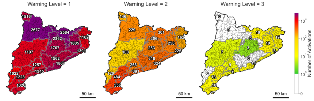
To evaluate this, the authors compared rainfall and wind-gust warnings issued by two meteorological agencies in Catalonia, Spain, against actual calls received by the 112 emergency service for flooding and wind damage over a six-year period (October 2018–February 2025).
The key findings reveal a significant gap in current operational models. While existing warnings successfully identify general regions of potential hazard, they suffer from a remarkably high number of false alarms. For example, Level 2 or higher rainfall warnings capture around 40% of all actual impacts, yet show a near 99% false alarm ratio at the local scale. This high frequency of false alarms can severely diminish public trust and reduce the ultimate usefulness of the warnings.
By highlighting both the potential and the limitations of current weather warnings, the research underscores the necessity of improving existing systems with localized, impact-driven approaches to better support emergency management.
- Published in New publications, News
RIGID: A Digital Tool for Civil Protection in Attica
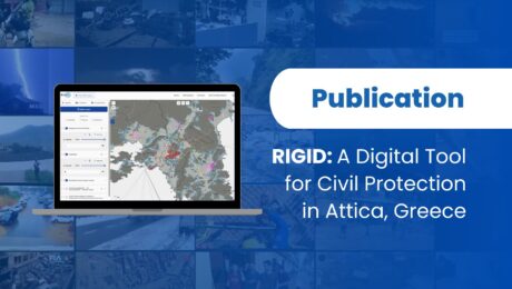
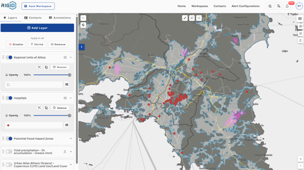
New research presents RIGID, the Rapid Intelligent Geospatial Integrated Disaster Management platform, a web-based tool designed to help civil protection authorities work with a common operational picture during multi-hazard situations. The study was conducted by Dimitris Tassopoulos, Artemis Lavasa, Ioakeim Konstantinidis, Petros Kafkias, Petros Gasteratos, Stavros Tekes and Anastasios Karakostas from DRAXIS Environmental S.A., within the framework of the GOBEYOND project.
During emergencies, authorities often need to consult many different systems to access forecasts, hazard maps, infrastructure information, shelters, administrative boundaries or traffic restrictions. This fragmentation can make it harder to understand what is happening, who is responsible for each area, and how decisions should be coordinated. RIGID addresses this challenge by bringing multi-hazard forecast indicators and regional and municipality-level operational data into one shared geospatial environment.
The platform has been implemented in the Region of Attica, Greece, as a local and regional decision-support tool for civil protection. Its data catalogue currently includes 291 layers, covering hazard and risk information, operational datasets, infrastructure, administrative boundaries and forecast layers. Users can combine relevant information in map-based workspaces, save these views, update them as a situation evolves, and share them with other stakeholders.
The study also presents preliminary findings from a workshop with civil protection stakeholders. Participants highlighted that the platform can help reduce data fragmentation, support shared situational awareness, and facilitate coordinated interpretation across different governance levels.
Through RIGID, GOBEYOND supports more effective disaster risk management by promoting the use of integrated digital tools for preparedness, coordination and informed decision-making.
- Published in New publications, News
One second to assess earthquakes impact at Campi Flegrei caldera
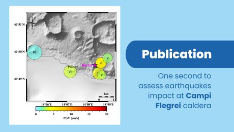
Can one second be a sufficient lapse to inform on the earthquake impact and potential damage? At Campi Flegrei caldera, a densely urbanized area of southern Italy, the answer is yes.
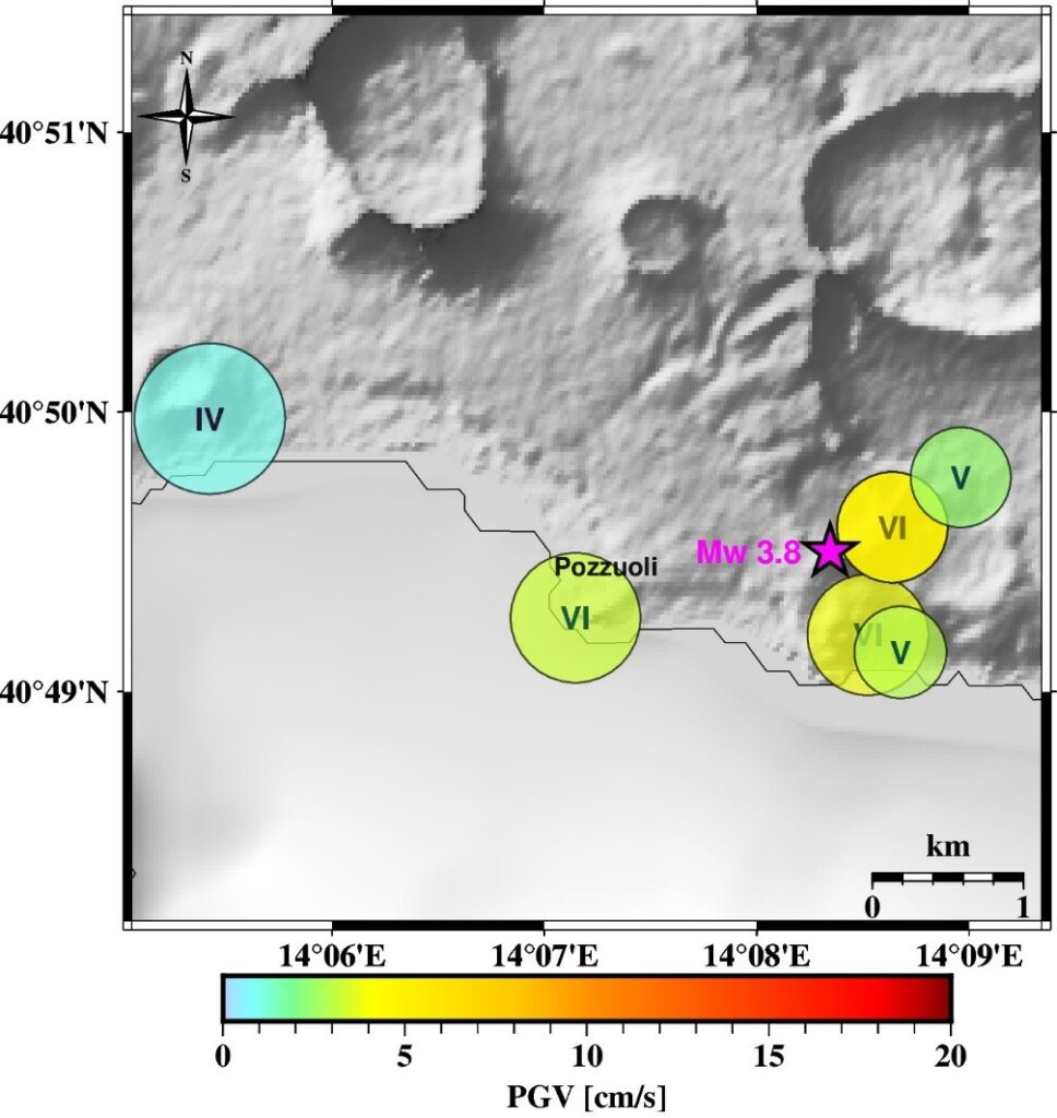
A new study shows that the very first second of shaking recorded by a seismic station already provides useful information about an ongoing earthquake in the Campi Flegrei. The research was carried out by Valeria Longobardi, Simona Colombelli and Aldo Zollo from the Department of Physics “Ettore Pancini” at the University of Naples Federico II, Italy, and was published in Scientific Reports, Nature Portfolio.
Campi Flegrei is one of the widest and most inhabited calderas on the planet. And it is far from dormant. Through cycles of bradyseism, the ground slowly lifts and subsides, reminding everyone living above it that the volcano is still active. In recent years, this restless behavior has been marked by an increasing number of earthquakes, often felt distinctly by the local population. The rapid uplift affecting the area (up to 2-3 cm/month) has already caused damage to structures and infrastructure, heightening the need for deeper knowledge and more effective risk management. In such a context, every second matters.
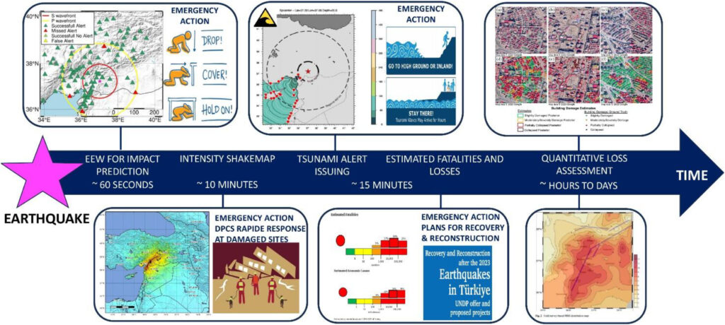
The recently published study shows that useful information can be extracted extremely quickly after an earthquake occurrence: using only the first second of the seismic signal, the proposed system can estimate how strong the earthquake is, how intense the shaking may be, and which nearby area may need attention first. In the framework of GOBEYOND, the first real time seismic antenna has been installed to develop the single-station-based early warning system. The algorithm was trained and calibrated using 3270 seismic records from 500 earthquakes that occurred in the Campi Flegrei area between 2016 and 2024. The system estimated earthquake magnitude with an uncertainty of 0.36 magnitude units and reached 84% of precision in peak ground motion estimates for clearly felt shaking (e.g. intensity level MMI=IV). The system also correctly identified the area of competence surrounding the seismic stations, where the predicted ground motion is expected to remain stable within ±50% of its value.
This research perfectly aligns with the goals of the GOBEYOND project because it helps turn scientific data into clear and timely information for emergency management. In a densely populated volcanic area, such as Campi Flegrei, even a few seconds can support faster situational awareness for Civil Protection Authorities and contribute to more targeted response actions during seismic crises.
- Published in New publications, News
Developing a rapid earthquake impact assessment procedure at European scale
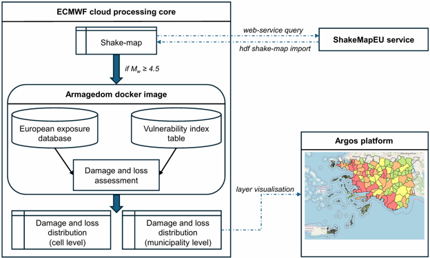
Research activity within GOBEYOND has resulted in a novel method for quickly assessing the impact of earthquakes across Europe. The goal is to provide timely and accurate information to help emergency services respond effectively. The resulting paper, with contributions from BRGM (Pierre Gehl, Caterina Negulescu, Romain Guidez, Samuel Auclair), ECMWF (Darren Snee, Cihan Sahin) and HYDS (Olga Villar, Xavier Llort), was recently published in the International Journal for Disaster Risk Reduction.
The proposed approach relies on two well-established tools and models at European scale: (i) the ShakeMapEU service, which rapidly estimates the seismic intensity following an earthquake, and (ii) the exposure database from the European Seismic Risk Model (ESRM20), which evaluates the vulnerability of buildings. The system categorizes buildings into 44 groups based on their structure, height, and design level. This helps in predicting how much damage buildings might suffer and how many people could be affected. The results are detailed and can be used at the local level, such as for towns or cities, making it easier for civil protection agencies to plan their response.
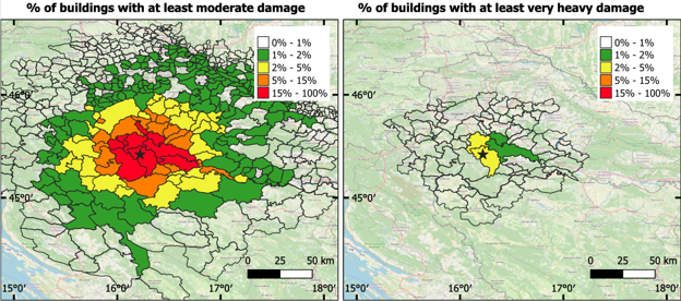
Comparisons with reports from recent damaging earthquakes in Europe show a reasonable agreement with estimates from the proposed approach, in terms of the number of damaged or destroyed buildings and the number of casualties. Two case studies, one in Croatia (Petrinja earthquake, 2020) and another in France (La Laigne earthquake, 2023), also demonstrate how the system can provide detailed impact assessments at the municipal level.
The paper also highlights the challenges in aligning the damage grades used in the model with the actual observations made after an earthquake, which often result from emergency tagging by first responders. This alignment is crucial for improving the accuracy of the model over time.
Overall, this study aims to foster a unified and efficient way to assess earthquake impacts across Europe, addressing the current fragmentation of national systems. It provides a first-level tool for emergency response and disaster management, especially for European countries that are not yet covered by dedicated earthquake rapid response systems.
- Published in New publications, News
Toward smarter early warnings: connecting risks across geo and weather hazards in Europe
A new study published in the Journal of the European Meteorological Society brings us one step closer to a key goal of the GOBEYOND project: building early warning systems that don’t just predict intensity of hazards but anticipate their real-world impacts.
Today, many warning systems work well for individual hazards such as floods, heatwaves, or earthquakes. But emergencies rarely happen in isolation, natural hazards may overlap, cascade, or unfold independently, challenging scientists, authorities, and concerned communities.
This research looks at how we can connect these systems into a more integrated, multi-risk approach, better suited to the complex realities faced by civil protection authorities and communities.
The study reviews a wide range of existing tools and technologies—from weather forecasting models to seismic monitoring and satellite or offshore observations. A central message clearly emerges: the most effective systems are those that combine hazard forecasts with information on exposure and vulnerability, in other words, not just what might happen, but who and what could be affected.
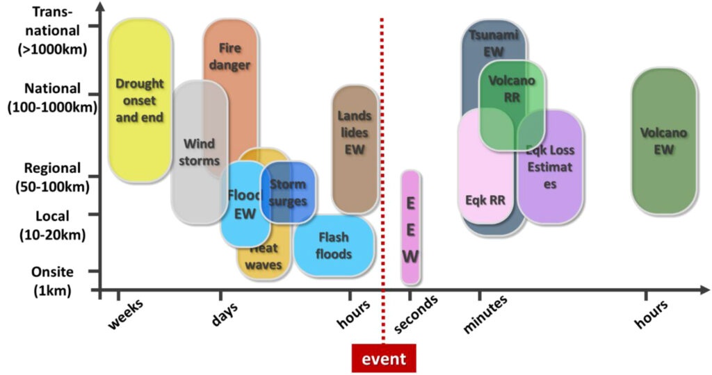
There has been major progress in recent years, including the use of machine learning, real-time data processing and mining, and probabilistic forecasts that better capture uncertainty. But important challenges remain. Data are often fragmented, systems are not always compatible and inter-operable, and different hazards span on very different time scales, from seconds for earthquakes to months for droughts.
Bringing everything together is not just a technical task. It also requires clear communication of uncertainty, effective decision-making processes, and strong coordination between institutions, meteorological services, geological agencies, and civil protection bodies. Equally important is designing user-friendly warning interfaces that help decision-makers and the public quickly understand complex risk information.
This is where GOBEYOND plays a crucial role. By identifying what works, and what still needs improvement, this research helps shape the next generation of early warning systems in Europe. The path forward is about improving existing systems, integrating them with innovative HW and SW components and connecting them through shared standards, interoperable tools, and better decision-support platforms.
The takeaway is encouraging: the science and technology are largely in place. The next step is making them work together, so that Europe can respond more effectively to multi-hazard and cascading risks, and ultimately better protect people, infrastructure, and communities.
Authors and affiliations
Aldo Zollo (Department of Physics, University of Naples Federico II, Italy); Fredrik Wetterhall (European Centre for Medium-Range Weather Forecasts, UK); Simona Colombelli (University of Naples Federico II, Italy); Samuel Auclair (BRGM, France); Séverine Bernardie (BRGM, France); Francesca Di Giuseppe (ECMWF, UK); Daniela De Gregorio (University of Naples Federico II / PLINIVS Study Centre, Italy); Francesca Linda Perelli (PLINIVS Study Centre, Italy); Claudia Di Napoli (ECMWF, UK); Siham El Garroussi (ECMWF, UK); Luca Elia (University of Naples Federico II, Italy); Pierre Gehl (BRGM, France); Anna Kampouri (National Observatory of Athens, Greece); Anastasios Karakostas (Aristotle University of Thessaloniki, Greece); Nikolaos Kekatos (Aristotle University of Thessaloniki, Greece); Anne Lemoine (BRGM, France); Valeria Longobardi (University of Naples Federico II, Italy); Erika Meléndez-Landaverde (UPC, Spain); Marc Berenguer (UPC, Spain); Evelyn Mühlhofer (MeteoSwiss, Switzerland); Stefano Nardone (PLINIVS Study Centre, Italy); Raffaele Rea (University of Naples Federico II, Italy); Jordi Roca (HYDS, Spain); Sonia Sorrentino (University of Naples Federico II, Italy); Liza Tapia (UPC, Spain); Max Wyss (ICES Foundation, Switzerland); Giulio Zuccaro (University of Naples Federico II / PLINIVS Study Centre, Italy); Karine Moreau (Predict Services, France); Daniel Sempere-Torres (UPC, Spain).
- Published in New publications, News
2nd GOBEYOND Workshop
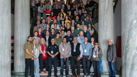
From 21 to 22 April 2026, the GOBEYOND community came together in Naples, Italy for the 2nd GOBEYOND Workshop—two days dedicated to collaboration, exchange of knowledge, and advancing innovation in multi-risk early warning systems.
The workshop welcomed a broad community of stakeholders, including civil protection authorities, first responders, researchers, policymakers, and practitioners. Hosted at the Università di Napoli Federico II, the event fostered open dialogue and hands-on collaboration around real-world risk challenges.
Through a series of engaging round tables and discussions, participants explored key challenges and solutions related to major natural hazards, including volcanic eruptions and tsunamis, rainfall-induced landslides, and seismic risk. Particular attention was given to the transition from early warning to actionable response, as well as to the complexities of managing impact-based, multi-risk warning systems.
Interactive poster sessions and live demonstrations offered a closer look at the GOBEYOND tools and pilot site developments. Participants had the opportunity to engage directly with solutions developed across multiple regions, such as Andalucía, Attica, Pozzuoli, Setúbal, and beyond, providing valuable feedback to further enhance their usability and impact.
A highlight of the programme was the field visit to the Campi Flegrei area, where participants experienced first-hand the unique geohazard conditions of the region, reinforcing the importance of connecting scientific knowledge and technology with operational practice.
The workshop concluded with an open discussion focusing on how to maximise the uptake and effective use of GOBEYOND solutions, underlining the value of continuous collaboration among stakeholders.
A warm thank you to all participants for their active contribution, and to the Università degli Studi di Napoli Federico II for the excellent organisation and hospitality.
- Published in Consortium Meetings, News
Wildfires in Attica: Managing a Multi-Risk Challenge in the Age of Climate Crisis
Written by Ioannis Kapris, Civil Protection, Region of Attica
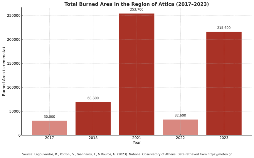
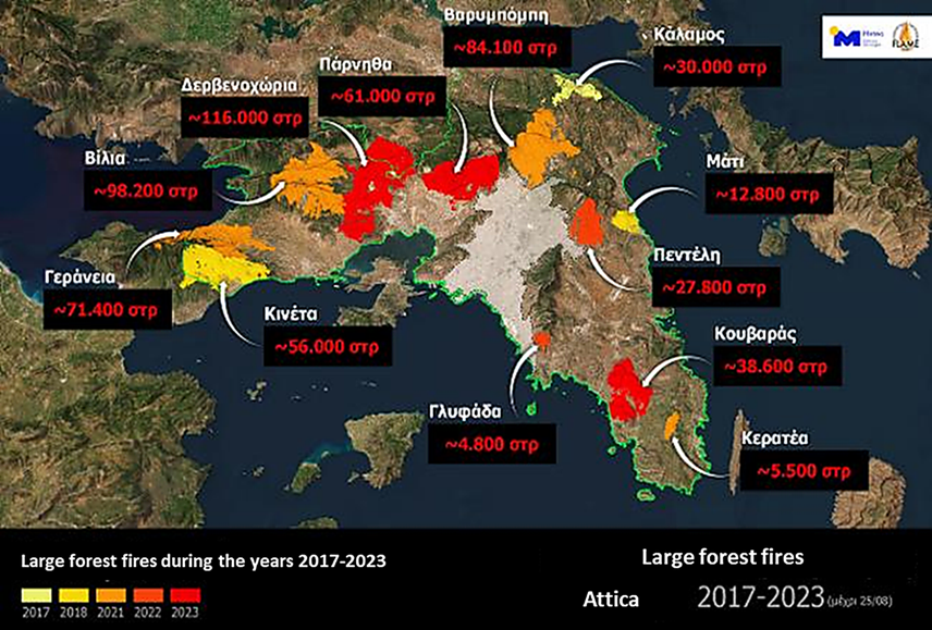
Between 2017 and 2023, over 1.23 million stremmata (123,000 hectares) of land burned in the Region of Attica due to 12 major wildfires, with more than 600,000 stremmata burned in just two of those fires (2021 and 2023). Alarmingly, 33% of Attica’s forested land has been lost in just seven years (Lagouvardos et al., 2023). These figures highlight the escalating wildfire threat under climate stress.
For the Directorate of Civil Protection of the Region of Attica, these numbers represent more than statistics—they are a call to action. Managing risk in one of Europe’s most densely populated regions is a complex and high-stakes mission. Attica, with a population density exceeding 1,000 inhabitants/km² (Eurostat, 2023), is home to over one-third of Greece’s population according to the 2021 census (ELSTAT, 2023). This demographic reality adds pressure to an already demanding operational landscape, requiring coordination across tightly interwoven residential and forested zones.
This challenges underscore the importance of impact-based, multi-risk early warning and response systems, like the systems that GOBEYOND is developing. Tools that integrate hazard forecasts with exposure and vulnerability data empower local authorities to act faster and smarter, protecting lives, forests, and urban areas alike. In a landscape where multiple hazards—fires, floods, heatwaves—interact, decision-support systems are not just useful; they are essential.
References:
• Lagouvardos, K., Kotroni, V., Giannaros, T., & Kouros, G. (2023). Εθνικό Αστεροσκοπείο Αθηνών – Μεγάλες δασικές πυρκαγιές Αττικής 2017–2023. Retrieved from https://meteo.gr
• Eurostat. (2023). Urban audit: Metropolitan regions population density. Retrieved from https://ec.europa.eu/eurostat
• Hellenic Statistical Authority (ELSTAT). (2023). 2021 Population Census – Final Results. Retrieved from https://www.statistics.gr
- Published in News
Advancing Impact-Based Early Warning in Switzerland: GOBEYOND’s Work in Zurich and Ticino
In the Swiss cantons of Zurich and Ticino, GOBEYOND partners are advancing the co-design of an adapted version of the project’s Multi-Risk Impact-based Early Warning System (MR-IEWS). Led by the Federal Office of Meteorology and Climatology MeteoSwiss, this work focuses on testing and refining an impact-based approach to risk communication through the development of a tailored prototype platform that can support faster, more informed responses in the face of natural hazards.
Understanding the Local Context
The two pilot regions offer contrasting conditions. Zurich is densely populated (1.5 million inhabitants), in an urban context, with relatively flat geography (altitude between 330 and 1290 m) and Swiss German speakers. On the other hand, the canton of Ticino is sparsely populated (0.3 million inhabitants), in a rural context, with mountainous relief (altitude between 190 and 3400 m) and Italian speakers.
The hazards these regions face range from storms, heavy precipitation and flash floods to heatwaves, wildfires, landslides, snow and avalanches. Not all hazards are equally relevant for Zurich and Ticino. A particular challenge lies in the warning system for water-related events: there is a gap between short-term thunderstorm alerts (typically issued up to one hour in advance) and long-duration rainfall warnings. This leaves fast-evolving hazards like flash floods and surface runoff largely unaddressed. Additionally, complex multi-hazard events—such as combinations of hail, intense rainfall, storms, and lightning—further complicate the response efforts of first responders.
Due to the decentralized, federal nature, the warning chains and responsibilities between communal and cantonal authorities and response entities are different between the two case study regions, and at times convoluted. Understanding these is key and an important component of the project.
From Hazard to Impact: Bridging the Gap
Switzerland already benefits from a strong foundation in risk communication through the GIN platform—a national, multi-hazard information system developed and operated by federal authorities. This platform, which has been in operational use for years, provides valuable hazard-based warnings to all Swiss cantons. However, it does not currently offer impact-specific insights, leaving a critical gap in decision-making support during natural hazard events.
GOBEYOND is working to bridge this gap, through a tailored version of the project’s Multi-Risk Impact-based Early Warning System (MR-IEWS), which will be developed specifically for Swiss needs. By combining hazard data with exposure and vulnerability indicators, the platform aims to give emergency services and local authorities the tools they need to anticipate consequences and respond more effectively.
Co-Creation Through Stakeholder Workshops
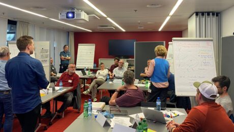
A key element of this work is the active involvement of local stakeholders. MeteoSwiss has organized a series of workshops to ensure that the platform is built around real-world operational needs. The first round of stakeholder engagement took place in September 2024, engaging key actors such as the Cantonal Police, Civil Protection Offices, Flood Protection Office, Ambulance Services, Fire Brigades, Natural Hazard Experts as well as the Community Mayor. These initial sessions gathered insights on existing challenges and the types of information that would support better preparedness and response.
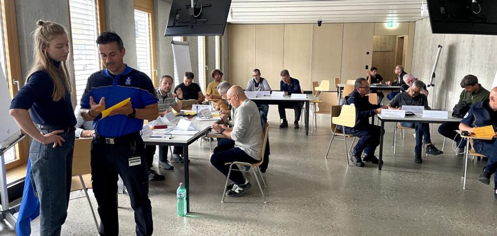
The dialogue continued in April 2025 with a second round of workshops in both pilot regions. These sessions focused on concrete use cases and scenarios where impact-based information could significantly enhance decision-making compared to conventional hazard warnings. Participants worked collaboratively to define how such systems could be used in practice, what data sources are most relevant, and how to align warning outputs with the needs and timing of different user groups.
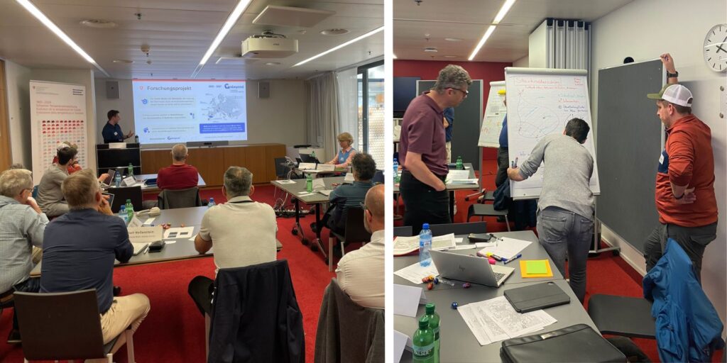
What’s happening in Zurich and Ticino is a clear example of the GOBEYOND philosophy: innovation driven by co-creation. By involving those on the front lines of emergency response, the project ensures that its tools are not only technically advanced but also tailored to the complex, real-world conditions in which they will be used.
The scenarios and use cases identified during the second round of workshops form the basis for the subsequent work. For selected use cases in both pilot regions, prototype applications providing targeted, impact-based information to specific user groups are developed. These prototypes are iteratively refined through discussions and workshops with local authorities. Following this process, the final solutions will be integrated into existing workflows at MeteoSwiss, with outputs made available through the Swiss national platform for natural hazards, GIN.
- Published in Living Labs, News
Publication: Rapid Fatality Estimates after Earthquakes in Western Mediterranean Countries for First Response
After large earthquakes worldwide, local communications are usually knocked out, but potential international rescuers need to know whether or not to respond. The International Centre for Earth Simulation Foundation, associate partner of the GOBEYOND project, issues estimates of the number of fatalities within 25 minutes, on average, for worldwide large earthquakes. In the project, they are working to reduce this delay to a few minutes by automating their calculations and including information on size and location of earthquakes from operators of regional seismograph networks because time matters in the race for first responders to rescue injured people.
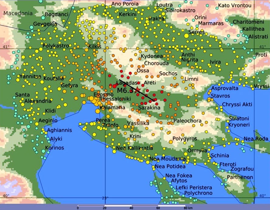
They have calibrated their calculation tool based on past earthquakes that have caused fatalities in Italy, Greece, Morocco and Spain; thus, they are confident that they can distinguish disastrous from inconsequential earthquakes in the Western Mediterranean area within minutes. An example of their estimate of shaking due to a magnitude M6.2 earthquake in Northern Greece is shown in Figure 1. The calculated intensities and fatalities match the observed ones.
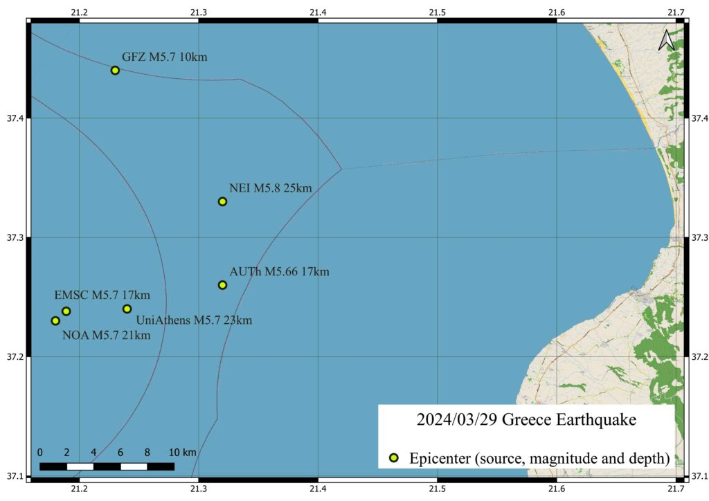
The greatest remaining challenge is to know an accurate location within minutes, which is needed for reliable estimates of fatalities. The variations of location estimates for an M5.7 in Greece reach 10 km and more (Figure 2). The only remedy is to obtain location estimates from regional seismograph networks capable of accurate locations.
This study, conducted by Max Wyss and Philippe Rosset from the International Centre for Earth Simulation Foundation, Geneva, Switzerland, was recently published in the Bulletin of the Seismological Society of America and is available on request from max@maxwyss.ch.
- Published in New publications, News
- 1
- 2