
A new study published in the Journal of the European Meteorological Society brings us one step closer to a key goal of the GOBEYOND project: building early warning systems that don’t just predict intensity of hazards but anticipate their real-world impacts.
Today, many warning systems work well for individual hazards such as floods, heatwaves, or earthquakes. But emergencies rarely happen in isolation, natural hazards may overlap, cascade, or unfold independently, challenging scientists, authorities, and concerned communities.
This research looks at how we can connect these systems into a more integrated, multi-risk approach, better suited to the complex realities faced by civil protection authorities and communities.
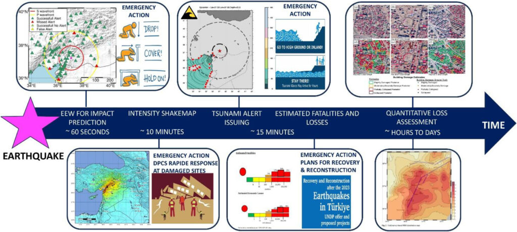
The study reviews a wide range of existing tools and technologies—from weather forecasting models to seismic monitoring and satellite or offshore observations. A central message clearly emerges: the most effective systems are those that combine hazard forecasts with information on exposure and vulnerability, in other words, not just what might happen, but who and what could be affected.
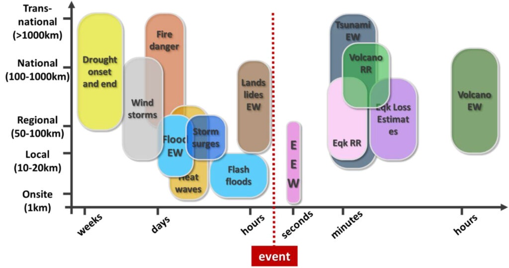
There has been major progress in recent years, including the use of machine learning, real-time data processing and mining, and probabilistic forecasts that better capture uncertainty. But important challenges remain. Data are often fragmented, systems are not always compatible and inter-operable, and different hazards span on very different time scales, from seconds for earthquakes to months for droughts.
Bringing everything together is not just a technical task. It also requires clear communication of uncertainty, effective decision-making processes, and strong coordination between institutions, meteorological services, geological agencies, and civil protection bodies. Equally important is designing user-friendly warning interfaces that help decision-makers and the public quickly understand complex risk information.
This is where GOBEYOND plays a crucial role. By identifying what works, and what still needs improvement, this research helps shape the next generation of early warning systems in Europe. The path forward is about improving existing systems, integrating them with innovative HW and SW components and connecting them through shared standards, interoperable tools, and better decision-support platforms.
The takeaway is encouraging: the science and technology are largely in place. The next step is making them work together, so that Europe can respond more effectively to multi-hazard and cascading risks, and ultimately better protect people, infrastructure, and communities.
Authors and affiliations
Aldo Zollo (Department of Physics, University of Naples Federico II, Italy); Fredrik Wetterhall (European Centre for Medium-Range Weather Forecasts, UK); Simona Colombelli (University of Naples Federico II, Italy); Samuel Auclair (BRGM, France); Séverine Bernardie (BRGM, France); Francesca Di Giuseppe (ECMWF, UK); Daniela De Gregorio (University of Naples Federico II / PLINIVS Study Centre, Italy); Francesca Linda Perelli (PLINIVS Study Centre, Italy); Claudia Di Napoli (ECMWF, UK); Siham El Garroussi (ECMWF, UK); Luca Elia (University of Naples Federico II, Italy); Pierre Gehl (BRGM, France); Anna Kampouri (National Observatory of Athens, Greece); Anastasios Karakostas (Aristotle University of Thessaloniki, Greece); Nikolaos Kekatos (Aristotle University of Thessaloniki, Greece); Anne Lemoine (BRGM, France); Valeria Longobardi (University of Naples Federico II, Italy); Erika Meléndez-Landaverde (UPC, Spain); Marc Berenguer (UPC, Spain); Evelyn Mühlhofer (MeteoSwiss, Switzerland); Stefano Nardone (PLINIVS Study Centre, Italy); Raffaele Rea (University of Naples Federico II, Italy); Jordi Roca (HYDS, Spain); Sonia Sorrentino (University of Naples Federico II, Italy); Liza Tapia (UPC, Spain); Max Wyss (ICES Foundation, Switzerland); Giulio Zuccaro (University of Naples Federico II / PLINIVS Study Centre, Italy); Karine Moreau (Predict Services, France); Daniel Sempere-Torres (UPC, Spain).