Developing a rapid earthquake impact assessment procedure at European scale
")
Research activity within GOBEYOND has resulted in a novel method for quickly assessing the impact of earthquakes across Europe. The goal is to provide timely and accurate information to help emergency services respond effectively. The resulting paper, with contributions from BRGM (Pierre Gehl, Caterina Negulescu, Romain Guidez, Samuel Auclair), ECMWF (Darren Snee, Cihan Sahin) and HYDS (Olga Villar, Xavier Llort), was recently published in the International Journal for Disaster Risk Reduction.
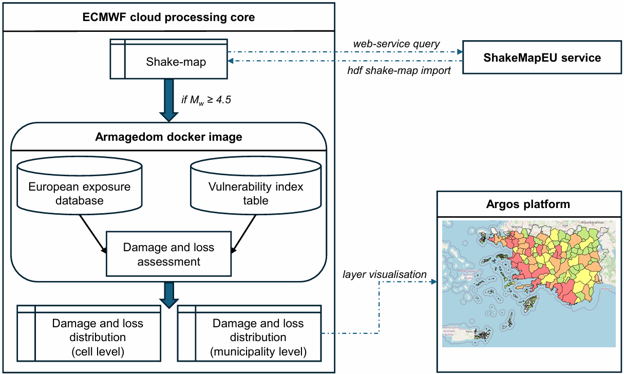
The proposed approach relies on two well-established tools and models at European scale: (i) the ShakeMapEU service, which rapidly estimates the seismic intensity following an earthquake, and (ii) the exposure database from the European Seismic Risk Model (ESRM20), which evaluates the vulnerability of buildings. The system categorizes buildings into 44 groups based on their structure, height, and design level. This helps in predicting how much damage buildings might suffer and how many people could be affected. The results are detailed and can be used at the local level, such as for towns or cities, making it easier for civil protection agencies to plan their response.
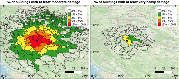
Comparisons with reports from recent damaging earthquakes in Europe show a reasonable agreement with estimates from the proposed approach, in terms of the number of damaged or destroyed buildings and the number of casualties. Two case studies, one in Croatia (Petrinja earthquake, 2020) and another in France (La Laigne earthquake, 2023), also demonstrate how the system can provide detailed impact assessments at the municipal level.
The paper also highlights the challenges in aligning the damage grades used in the model with the actual observations made after an earthquake, which often result from emergency tagging by first responders. This alignment is crucial for improving the accuracy of the model over time.
Overall, this study aims to foster a unified and efficient way to assess earthquake impacts across Europe, addressing the current fragmentation of national systems. It provides a first-level tool for emergency response and disaster management, especially for European countries that are not yet covered by dedicated earthquake rapid response systems.
- Published in New publications, News
Toward smarter early warnings: connecting risks across geo and weather hazards in Europe
")
A new study published in the Journal of the European Meteorological Society brings us one step closer to a key goal of the GOBEYOND project: building early warning systems that don’t just predict intensity of hazards but anticipate their real-world impacts.
Today, many warning systems work well for individual hazards such as floods, heatwaves, or earthquakes. But emergencies rarely happen in isolation, natural hazards may overlap, cascade, or unfold independently, challenging scientists, authorities, and concerned communities.
This research looks at how we can connect these systems into a more integrated, multi-risk approach, better suited to the complex realities faced by civil protection authorities and communities.
The study reviews a wide range of existing tools and technologies—from weather forecasting models to seismic monitoring and satellite or offshore observations. A central message clearly emerges: the most effective systems are those that combine hazard forecasts with information on exposure and vulnerability, in other words, not just what might happen, but who and what could be affected.
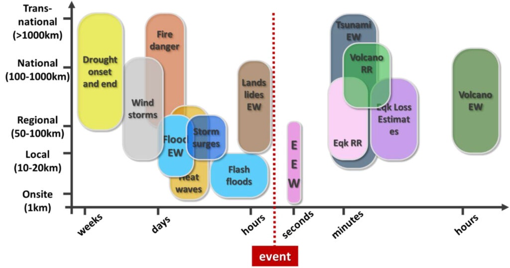
There has been major progress in recent years, including the use of machine learning, real-time data processing and mining, and probabilistic forecasts that better capture uncertainty. But important challenges remain. Data are often fragmented, systems are not always compatible and inter-operable, and different hazards span on very different time scales, from seconds for earthquakes to months for droughts.
Bringing everything together is not just a technical task. It also requires clear communication of uncertainty, effective decision-making processes, and strong coordination between institutions, meteorological services, geological agencies, and civil protection bodies. Equally important is designing user-friendly warning interfaces that help decision-makers and the public quickly understand complex risk information.
This is where GOBEYOND plays a crucial role. By identifying what works, and what still needs improvement, this research helps shape the next generation of early warning systems in Europe. The path forward is about improving existing systems, integrating them with innovative HW and SW components and connecting them through shared standards, interoperable tools, and better decision-support platforms.
The takeaway is encouraging: the science and technology are largely in place. The next step is making them work together, so that Europe can respond more effectively to multi-hazard and cascading risks, and ultimately better protect people, infrastructure, and communities.
Authors and affiliations
Aldo Zollo (Department of Physics, University of Naples Federico II, Italy); Fredrik Wetterhall (European Centre for Medium-Range Weather Forecasts, UK); Simona Colombelli (University of Naples Federico II, Italy); Samuel Auclair (BRGM, France); Séverine Bernardie (BRGM, France); Francesca Di Giuseppe (ECMWF, UK); Daniela De Gregorio (University of Naples Federico II / PLINIVS Study Centre, Italy); Francesca Linda Perelli (PLINIVS Study Centre, Italy); Claudia Di Napoli (ECMWF, UK); Siham El Garroussi (ECMWF, UK); Luca Elia (University of Naples Federico II, Italy); Pierre Gehl (BRGM, France); Anna Kampouri (National Observatory of Athens, Greece); Anastasios Karakostas (Aristotle University of Thessaloniki, Greece); Nikolaos Kekatos (Aristotle University of Thessaloniki, Greece); Anne Lemoine (BRGM, France); Valeria Longobardi (University of Naples Federico II, Italy); Erika Meléndez-Landaverde (UPC, Spain); Marc Berenguer (UPC, Spain); Evelyn Mühlhofer (MeteoSwiss, Switzerland); Stefano Nardone (PLINIVS Study Centre, Italy); Raffaele Rea (University of Naples Federico II, Italy); Jordi Roca (HYDS, Spain); Sonia Sorrentino (University of Naples Federico II, Italy); Liza Tapia (UPC, Spain); Max Wyss (ICES Foundation, Switzerland); Giulio Zuccaro (University of Naples Federico II / PLINIVS Study Centre, Italy); Karine Moreau (Predict Services, France); Daniel Sempere-Torres (UPC, Spain).
- Published in New publications, News
Publication: Rapid Fatality Estimates after Earthquakes in Western Mediterranean Countries for First Response

After large earthquakes worldwide, local communications are usually knocked out, but potential international rescuers need to know whether or not to respond. The International Centre for Earth Simulation Foundation, associate partner of the GOBEYOND project, issues estimates of the number of fatalities within 25 minutes, on average, for worldwide large earthquakes. In the project, they are working to reduce this delay to a few minutes by automating their calculations and including information on size and location of earthquakes from operators of regional seismograph networks because time matters in the race for first responders to rescue injured people.
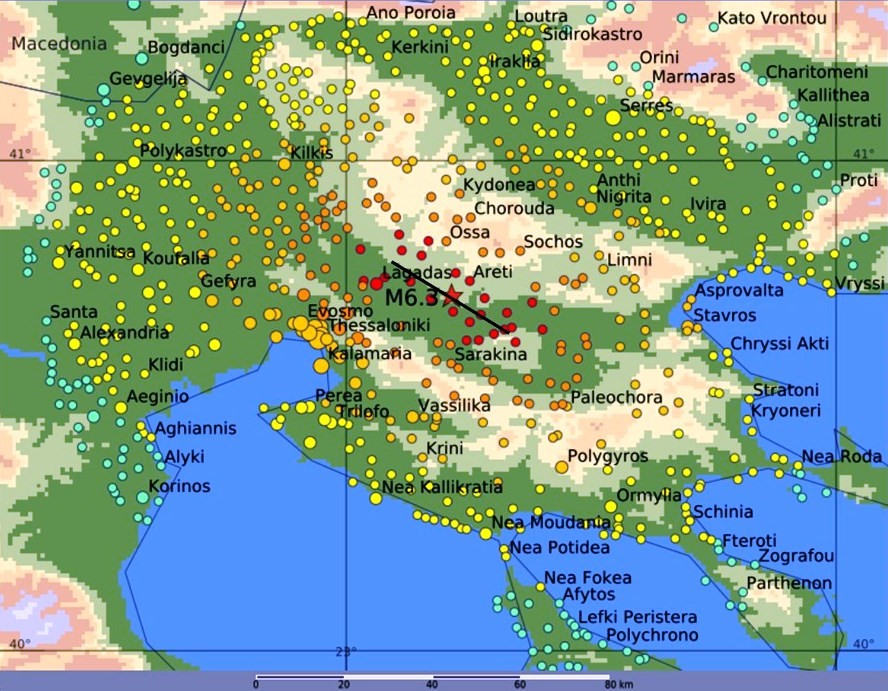
They have calibrated their calculation tool based on past earthquakes that have caused fatalities in Italy, Greece, Morocco and Spain; thus, they are confident that they can distinguish disastrous from inconsequential earthquakes in the Western Mediterranean area within minutes. An example of their estimate of shaking due to a magnitude M6.2 earthquake in Northern Greece is shown in Figure 1. The calculated intensities and fatalities match the observed ones.
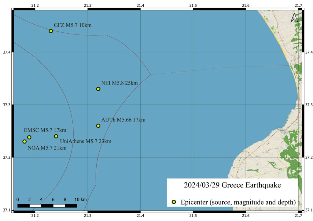
The greatest remaining challenge is to know an accurate location within minutes, which is needed for reliable estimates of fatalities. The variations of location estimates for an M5.7 in Greece reach 10 km and more (Figure 2). The only remedy is to obtain location estimates from regional seismograph networks capable of accurate locations.
This study, conducted by Max Wyss and Philippe Rosset from the International Centre for Earth Simulation Foundation, Geneva, Switzerland, was recently published in the Bulletin of the Seismological Society of America and is available on request from max@maxwyss.ch.
- Published in New publications, News
Publication: Groundbreaking Research Unveils New Earthquake Early Warning System Using Initial Seismic Signals

New research reveals that the initial signals emitted during an earthquake can effectively track the evolution of fault rupture in real-time, offering the potential to alert populations before destructive seismic waves arrive. This study, conducted by Raffaele Rea, Simona Colombelli, Luca Elia, and Aldo Zollo from the Department of Physics at the University of Naples Federico II, was recently published in Nature Communications Earth & Environment.
During an earthquake, seismic waves originate deep underground, propagating through the Earth and reaching the surface within seconds, causing severe damage to people, buildings, and infrastructure. Although earthquake prediction remains elusive, predicting the impact of these events and sending warnings to specific areas before the arrival of destructive waves is possible through Earthquake Early Warning (EEW) systems.
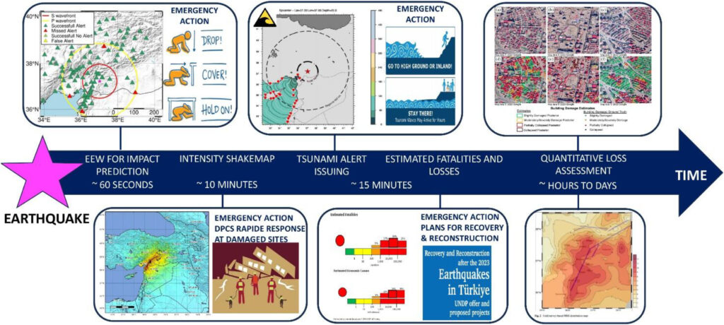
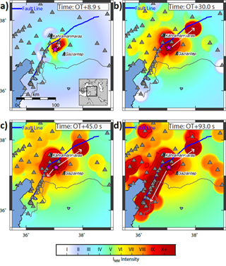
In their recent paper, the team demonstrates the effectiveness of their advanced EEW system, applied to the magnitude 7.8 earthquake that struck the Turkey-Syria border region in February 2023. Their approach uses a sophisticated ground-motion prediction method based on the detection of primary (P) waves, which allows for the real-time identification of areas where ground shaking is likely to exceed predefined thresholds.
The system’s performance was validated through a retrospective analysis of hundreds of accelerometer readings near the earthquake’s source. Remarkably, an alert was generated approximately 10 seconds after the earthquake’s origin, with a 95% success rate in notifying sites within the affected zone, providing lead times of 10 to 60 seconds in high-risk areas. The study shows that the anticipated strong shaking region could be reliably identified approximately 20 seconds after the rupture initiation.
As time progresses, the system precisely outlines the seismic rupture’s development, highlighting its bilateral propagation in the northeast-southwest direction, as inferred from kinematic source models.
These findings indicate that P-wave-based EEW systems can deliver timely and accurate alerts, significantly reducing potential damage and enhancing safety in earthquake-prone regions.
You can read the article at https://www.nature.com/articles/s43247-024-01507-3
- Published in New publications, News
Publication: User-based analysis of practitioners’ needs to make earthquake warnings more actionable
")
In response to seismic risk, particularly in the vulnerable French West Indies, researchers Samuel Auclair, Aude Nachbaur, Pierre Gehl, Yoann Legendre, and Benoit Vittecoq from BRGM (French Geological Survey) collaborated with local stakeholders from Martinique (Caribbean) to assess the relevance and feasibility of implementing three advanced earthquake alert systems. Their study evaluated three main types of solutions: Operational Earthquake Forecasting (OEF) for probabilistic forecasts, Earthquake Early Warning (EEW) for imminent tremor alerts, and Rapid Response to Earthquakes (RRE) to assess post-quake impacts. This approach aligns with the goals of the GOBEYOND project, focusing on enhancing disaster resilience and supporting user-centered alert systems across multiple contexts.
The research applied a user-centered, multi-step methodology involving online surveys, targeted interviews, and workshops with key stakeholders in Martinique. The study revealed that while OEF could improve risk awareness, its effectiveness is hindered by public skepticism and challenges in communicating probabilistic forecasts. EEW was particularly valued for its ability to trigger immediate protective measures, but stakeholders noted that brief warning times could limit its impact. The RRE system was widely recognized as crucial for immediate post-earthquake assessments, aiding in prioritizing emergency responses.
Key findings highlighted the need for an “informational continuum” integrating these systems to provide cohesive support across pre-, during-, and post-earthquake phases. Stakeholders emphasized that false alarms and inadequate communication could erode trust, underscoring the importance of involving end-users in designing alert dissemination methods.
Overall, this research supports the GOBEYOND mission by providing actionable insights for implementing effective, user-centered seismic alert systems in the French West Indies and similar regions globally.
You can read the article at https://doi.org/10.1016/j.ijdrr.2024.104932.
- Published in New publications, News