Publication: Rapid Fatality Estimates after Earthquakes in Western Mediterranean Countries for First Response

After large earthquakes worldwide, local communications are usually knocked out, but potential international rescuers need to know whether or not to respond. The International Centre for Earth Simulation Foundation, associate partner of the GOBEYOND project, issues estimates of the number of fatalities within 25 minutes, on average, for worldwide large earthquakes. In the project, they are working to reduce this delay to a few minutes by automating their calculations and including information on size and location of earthquakes from operators of regional seismograph networks because time matters in the race for first responders to rescue injured people.
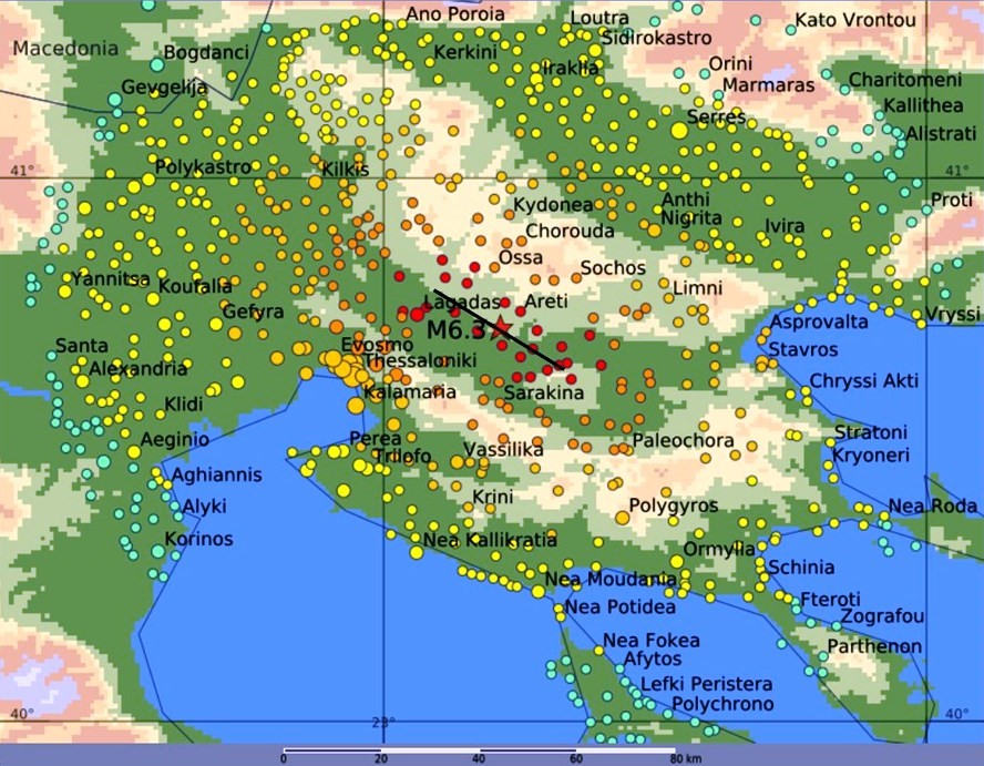
They have calibrated their calculation tool based on past earthquakes that have caused fatalities in Italy, Greece, Morocco and Spain; thus, they are confident that they can distinguish disastrous from inconsequential earthquakes in the Western Mediterranean area within minutes. An example of their estimate of shaking due to a magnitude M6.2 earthquake in Northern Greece is shown in Figure 1. The calculated intensities and fatalities match the observed ones.
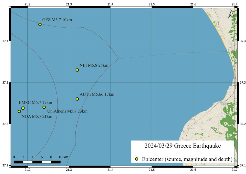
The greatest remaining challenge is to know an accurate location within minutes, which is needed for reliable estimates of fatalities. The variations of location estimates for an M5.7 in Greece reach 10 km and more (Figure 2). The only remedy is to obtain location estimates from regional seismograph networks capable of accurate locations.
This study, conducted by Max Wyss and Philippe Rosset from the International Centre for Earth Simulation Foundation, Geneva, Switzerland, was recently published in the Bulletin of the Seismological Society of America and is available on request from max@maxwyss.ch.
- Published in New publications, News
Publication: Groundbreaking Research Unveils New Earthquake Early Warning System Using Initial Seismic Signals

New research reveals that the initial signals emitted during an earthquake can effectively track the evolution of fault rupture in real-time, offering the potential to alert populations before destructive seismic waves arrive. This study, conducted by Raffaele Rea, Simona Colombelli, Luca Elia, and Aldo Zollo from the Department of Physics at the University of Naples Federico II, was recently published in Nature Communications Earth & Environment.
During an earthquake, seismic waves originate deep underground, propagating through the Earth and reaching the surface within seconds, causing severe damage to people, buildings, and infrastructure. Although earthquake prediction remains elusive, predicting the impact of these events and sending warnings to specific areas before the arrival of destructive waves is possible through Earthquake Early Warning (EEW) systems.
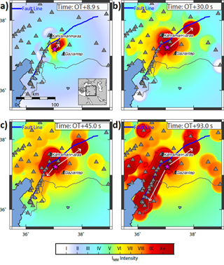
In their recent paper, the team demonstrates the effectiveness of their advanced EEW system, applied to the magnitude 7.8 earthquake that struck the Turkey-Syria border region in February 2023. Their approach uses a sophisticated ground-motion prediction method based on the detection of primary (P) waves, which allows for the real-time identification of areas where ground shaking is likely to exceed predefined thresholds.
The system’s performance was validated through a retrospective analysis of hundreds of accelerometer readings near the earthquake’s source. Remarkably, an alert was generated approximately 10 seconds after the earthquake’s origin, with a 95% success rate in notifying sites within the affected zone, providing lead times of 10 to 60 seconds in high-risk areas. The study shows that the anticipated strong shaking region could be reliably identified approximately 20 seconds after the rupture initiation.
As time progresses, the system precisely outlines the seismic rupture’s development, highlighting its bilateral propagation in the northeast-southwest direction, as inferred from kinematic source models.
These findings indicate that P-wave-based EEW systems can deliver timely and accurate alerts, significantly reducing potential damage and enhancing safety in earthquake-prone regions.
You can read the article at https://www.nature.com/articles/s43247-024-01507-3
- Published in New publications, News
Publication: User-based analysis of practitioners’ needs to make earthquake warnings more actionable
")
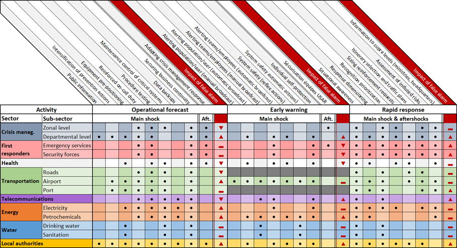
In response to seismic risk, particularly in the vulnerable French West Indies, researchers Samuel Auclair, Aude Nachbaur, Pierre Gehl, Yoann Legendre, and Benoit Vittecoq from BRGM (French Geological Survey) collaborated with local stakeholders from Martinique (Caribbean) to assess the relevance and feasibility of implementing three advanced earthquake alert systems. Their study evaluated three main types of solutions: Operational Earthquake Forecasting (OEF) for probabilistic forecasts, Earthquake Early Warning (EEW) for imminent tremor alerts, and Rapid Response to Earthquakes (RRE) to assess post-quake impacts. This approach aligns with the goals of the GOBEYOND project, focusing on enhancing disaster resilience and supporting user-centered alert systems across multiple contexts.
The research applied a user-centered, multi-step methodology involving online surveys, targeted interviews, and workshops with key stakeholders in Martinique. The study revealed that while OEF could improve risk awareness, its effectiveness is hindered by public skepticism and challenges in communicating probabilistic forecasts. EEW was particularly valued for its ability to trigger immediate protective measures, but stakeholders noted that brief warning times could limit its impact. The RRE system was widely recognized as crucial for immediate post-earthquake assessments, aiding in prioritizing emergency responses.
Key findings highlighted the need for an “informational continuum” integrating these systems to provide cohesive support across pre-, during-, and post-earthquake phases. Stakeholders emphasized that false alarms and inadequate communication could erode trust, underscoring the importance of involving end-users in designing alert dissemination methods.
Overall, this research supports the GOBEYOND mission by providing actionable insights for implementing effective, user-centered seismic alert systems in the French West Indies and similar regions globally.
You can read the article at https://doi.org/10.1016/j.ijdrr.2024.104932.
- Published in New publications, News