Aldo Zollo – Department of Physics University of Naples Federico II
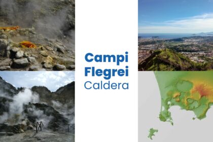
The Campi Flegrei caldera in southern Italy is one of the most fascinating and complex volcanic systems on Earth. Nestled in the metropolitan area of Naples, it is home to nearly half a million people. Far from being a dormant relic, Campi Flegrei remains lively and unpredictable, showing signs of unrest that include ground uplift, seismic activity, and gas emissions. These signals reflect the caldera’s intricate subsurface processes, where magma interacts with a gas-rich hydrothermal system, creating pressure changes capable of reshaping the landscape above and posing both geological and societal challenges.
A Brief Geological History
Campi Flegrei has a nested caldera structure formed by two major explosive eruptions: the Campanian Ignimbrite, about 39,000 years ago, and the Neapolitan Yellow Tuff, about 14,500 years ago. Each eruption expelled massive amounts of volcanic material and left behind a depression—called a caldera—whose boundaries now extend partly beneath the Bay of Naples. After these catastrophic events, over 70 smaller eruptions have occurred within the caldera in the last 15,000 years. Many of them were localized along structural weak points, where faults or fractures provided easier pathways for magma or high-pressure gases to rise.
This area, particularly the central part of Pozzuoli, has been marked by repeated episodes of uplift and subsidence—known as bradyseism—often accompanied by earthquakes. Since about 10,500 years ago, periods of unrest have been tightly linked to caldera resurgence in the central sector. When measured using modern geodetic techniques, the ground deformation shows a classic “bell-shaped” pattern centered on Pozzuoli, where the largest vertical changes occur.
Bradyseism Through the Decades
Over the past 70 years, Campi Flegrei has undergone several significant bradyseismic cycles. Two major uplift episodes in 1970–72 and 1982–84 triggered more than 20,000 earthquakes, causing extensive damage to buildings, roads, and pipelines, and forcing the evacuation of part of Pozzuoli’s historic center. After 1985, the caldera subsided for two decades, and seismicity subsided with it. However, since 2005, a new phase of ground uplift has been in progress. At times, this uplift rate has reached as high as 15 millimeters per month, correlating with noticeable increases in the frequency and magnitude of earthquakes.
As of 2023, deformation rates have risen to about 1–1.5 centimeters per month, with up to 1,000 earthquakes recorded monthly. While most earthquakes are small (magnitude 1 or less), they have recently included events in the magnitude 3–4 range, and one notable earthquake in May 2024 reached magnitude 4.4. Although this shaking is felt strongly near the epicenters, it typically decreases rapidly only a few kilometers away, thus limiting widespread structural damage. Still, scientists and civil authorities remain vigilant, as even moderate earthquakes can pose risks in an urban setting.
Why the Ground Moves: Magma or Hydrothermal Fluids?
One of the biggest scientific debates at Campi Flegrei centers on the source of the unrest. Some researchers propose that magma intruding at shallow depths increases the pressure below the surface, lifting the ground and shaking the region. Others contend that hydrothermal fluids, rich in water and gas, explain the phenomenon. These fluids can become pressurized by deeper injections of gas from magma reservoirs and trigger the reactivation of fractures near the surface.
Seismic reflection studies and three-dimensional tomography did not detect any substantial magma accumulation at depths where most unrest occurs, typically less than 3 kilometers. Instead, these surveys reveal regions with high gas content or other evidence of hydrothermal activity. This does not rule out the possibility that small pockets of magma may exist at shallow depths, but it underscores the likelihood that fluid migration—and the pressure changes it causes—plays a central role in shaping Campi Flegrei’s unrest.
Mapping Faults and Relocating Earthquakes
To better understand the structure and behavior of Campi Flegrei, scientists use precise earthquake relocation methods, which refine hypocenter positions by reducing uncertainties in seismic data. This approach allows researchers to identify the specific faults and fractures activated during uplift episodes. Recent multi-scale relocation studies reveal an elliptical pattern to the seismicity, with shallow earthquakes beneath Solfatara-Pisciarelli and northern Pozzuoli. Offshore, earthquake depths generally increase.
These relocations also help experts evaluate the potential for larger events. Based on the geometry of the faults and historical data, ruptures could occur that reach moment magnitudes between 4.4 and 5.1. While not as powerful as the large earthquakes seen in other parts of Italy, a magnitude 5 event in a densely populated urban area remains a critical concern for civil protection agencies and local communities.
A Multi-Hazard Perspective
Beyond the risk of ground shaking, Campi Flegrei’s reawakened hydrothermal system, along with its history of moderate-size eruptions, calls for a broader assessment of volcanic hazards. Even a modest eruption could send ballistic blocks into the air, generate pyroclastic flows, and deposit ash across Naples. In many respects, the most common scenario might not involve fresh magma reaching the surface at all. Instead, phreatic or hydrothermal explosions—triggered when high-pressure fluids encounter cooler groundwater or come into contact with a confining layer—could still wreak havoc.
Historical accounts, especially those from the last eruption in 1538 at Monte Nuovo, indicate that significant uplift and persistent seismicity preceded volcanic events. This reaffirms that monitoring seismic activity is crucial for detecting early signs of volcanic unrest. However, not every uplift episode leads to an eruption; indeed, many phases of bradyseism over the last half-century ended without magma breaching the surface.
How Scientists Monitor and Model the Caldera
The National Institute of Geophysics and Volcanology (INGV) and other agencies maintain an extensive observing system at Campi Flegrei. Instruments measure ground deformation, seismic waves, gravity variations, gas emissions, and chemical changes in fumaroles and groundwater. Data arrive in real time, enabling scientists to detect anomalies quickly and send alerts to Civil Protection authorities, who coordinate evacuation plans if necessary.
To better plan for potential hazards, researchers combine observational data with advanced modeling tools. For instance, probabilistic analyses use historical patterns of bradyseism, seismic swarms, and eruptions to gauge how likely future unrest events might be. Agent-based simulations model how people and infrastructure would respond to evacuation orders or disruptions caused by ground deformation and shaking. Meanwhile, engineers conduct structural assessments to see if buildings in the region can withstand scenario-based earthquakes.
Risk Management and Resilience
Modern building codes typically focus on earthquakes expected over a multi-decade time scale, but the relatively small earthquakes at Campi Flegrei, occurring during bradyseism, can still cause localized damage. Recent research points out that standard seismic design may need to consider local, near-surface fault ruptures triggered by ground uplift. Reinforced concrete buildings fare reasonably well against moderate ground shaking, but older structures might require retrofitting to reduce collapse risks.
Risk management strategies must also acknowledge the unique interplay of multiple hazards: volcanic activity, seismicity, and ground deformation. Evacuation planning, infrastructural upgrades, and the clear communication of risks to residents all figure into the region’s civil defense strategies. The Italian Civil Protection system has developed various alert levels, which escalate if monitored data suggest that unrest is intensifying or an eruption becomes more likely.
Looking Ahead
Ongoing scientific efforts aim to refine the understanding of Campi Flegrei’s inner workings. By integrating high-precision earthquake relocations, satellite-based ground deformation surveys, and advanced geochemical analyses, researchers can better forecast how pressure builds and dissipates underground. These insights help narrow down the scenarios in which seismicity or ground deformation might escalate to an actual eruption.
A flexible, multi-hazard framework further supports these scientific advances, combining knowledge of past eruptions, ongoing ground deformation, and local infrastructure vulnerabilities. Agent-based and probabilistic simulations help decision-makers test different emergency scenarios—ranging from phreatic explosions to modest magmatic eruptions—to ensure rapid responses that minimize the risk to both people and property.
Ultimately, while Campi Flegrei’s restless nature cannot be tamed, it can be better understood. Through sustained research, advanced monitoring, and smart, scenario-based planning, the million residents who live, work, and thrive in this volcanic wonderland can rest a bit easier, knowing that science and preparedness stand ready to help them face the next chapter of Campi Flegrei’s ongoing story.


Interesting points about navigating complex gaming systems! The emphasis on secure registration at 789win surf reminds me how crucial user empowerment is for a good experience. It’s all about building trust & accessibility.